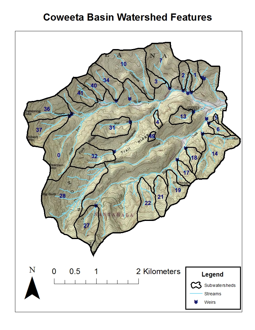
| Water Shed | Stream | Area | First Record | Notch | Elevation At Weir | Max Elevation | Max Discharge | Aspect | Summary |
|---|
| 1 | Copper Branch | 16 ha | 6/13/1934 | 90 V-notch | 705 m | 988 m | 2.29 m3sec-1km-2 | South | Entire watershed prescribed burned in April, 1942. All trees and shrubs within the cove-hardwood type (areas adjacent to stream) deadened with chemicals in 1954. This treatment represented 25% of both land and area and total watershed basal area. Retreated as necessary for three consecutive growing seasons. All trees and shrubs cut and burned in 1956-57, no products removed; white pine planted in 1957. In subsequent years, pine released from hardwood competition by cutting and chemicals as necessary. |
| 2 | Shope Branch | 12 ha | 6/22/1934 | 90 V-notch | 709 m | 1004 m | 2.41 m3sec-1km-2 | SSE | Controls with mixed hardwoods stands remaining undisturbed since 1927. |
| 3 | Little Hurricane | 9 ha | 7/5/1934 | CIA deep notch | 739 m | 931 m | 20.27 m3sec-1km-2 | East | All vegetation cut and burned or removed from the watershed in 1940. Unregulated agriculture (farming and grazing) on 6 ha for a 12-year period, followed by planting yellow poplar and white pine. |
| 6 | Sawmill Branch | 9 ha | 7/10/1934 | 90 V-notch | 696 m | 905 m | 3.76 m3sec-1km-2 | NW | All woody vegetation cut and scattered in the zone 5 m vertically above the stream; reduced total watershed basal area 12%. Clearcut in 1958, products removed and remaining residue piled and burned. Surface soil scarified, watershed planted to grass, limed and fertilized in 1959; fertilized again in 1965. Grass herbicide treatment in 1966 and 1967; watershed subsequently reverted to successional vegetation. |
| 7 | Big Hurricane | 59 ha | 7/31/1934 | 90 V-notch | 722 m | 1077 m | 2.18 m3sec-1km-2 | South | Lower portion of watershed grazed by an average of six cattle during 5-month period each year from 1941-1952. Commercially clearcut and cable logged in 1977. |
| 10 | Camprock Creek | 86 ha | 3/7/1936 | 120 V-notch | 742 m | 1159 m | 0.85 m3sec-1km-2 | SSE | Exploitive selective logging during the period 1942-1956 with a 30% reduction in total watershed basal area.Stream flow data were collected from 07 March 1936 to October 1954. The weir was removed in 1976 while building the lower access road in preparation for the watershed 7 logging treatment. |
| 11 | Carpenter Creek | 16 ha | 3/12/1936 | 120 V-notch | 725 m | 912 m | 1.09 m3sec-1km-2 | ENE | All woody vegetation cut in 1939 and allowed to re-grow until 1962 when the watershed was again clearcut; no products removed in either treatments. |
| 14 | Hugh White Branch | 61 ha | 5/26/1936 | 120 V-notch | 707 m | 992 m | 1.11 m3sec-1km-2 | NW | Control with mixed hardwood stands remaining undisturbed since 1927. |
| 17 | Hertzler Branch | 13 ha | 6/6/1936 | 90 V-notch | 760 m | 1021 m | 1.06 m3sec-1km-2 | Northwest | All woody vegetation cut in 1940 and re-growth cut annually thereafter in most years until 1955; no products removed. White pine planted in 1956 and released from hardwood competition as required with cutting or chemicals. |
| 19 | Snake Den Branch | 28 ha | 5/16/1941 | 120 V-notch | 796 m | 1119 m | 1.28 m3sec-1km-2 | Northwest | All woody vegetation cut in 1940 and re-growth cut annually thereafter in most years until 1955; no products removed. White pine planted in 1956 and released from hardwood competition as required with cutting or chemicals. |
| 21 | Sheep Rock Branch | 24 ha | 7/22/1938 | 120 V-notch | 823 m | 1174 m | 1.79 m3sec-1km-2 | North | Control with mixed hardwood stands remaining undisturbed since 1927. |
| 22 | Lick Branch | 34 ha | 2/18/1937 | 120 V-notch | 847 m | 1244 m | 1.75 m3sec-1km-2 | North | All woody vegetation within alternate 10 m strips deadened by chemicals in 1955; reduced total watershed area 50%. Treatment repeated from 1956 to 1960 as required to maintain conditions. |
| 27 | Hard Luck Creek | 39 ha | 11/2/1946 | 120 V-notch | 1061 m | 1454 m | 5.65 m3sec-1km-2 | NNE | Control, but partially defoliated by fall cankerworm infestation from 1972 to 1979. |
| 28 | Henson Creek No.2 | 144 ha | 5/31/1937 | 1.83 m Rectangle | 964 m | 1551 m | 2.03 m3sec-1km-2 | East | Multiple use demonstration comprised of commercial harvest with clear cutting on 77 ha, thinning on 39 ha of the cove forest and no cutting on 28 ha; products removed. |
| 31 | Mill Branch | 34 ha | 10/1/1981 | 120 V-notch | 869 m | 1146 m | NA | ENE | Gage active; no history of manipulations. |
| 32 | Cunningham Creek No.2 | 41 ha | 10/25/1941 | 120 V-notch | 920 m | 1236 m | 1.35 m3sec-1km-2 | ESE | Control with mixed hardwoods stands remaining undisturbed since 1927. |
| 34 | Bee Branch | 33 ha | 10/31/1938 | 120 V-notch | 866 m | 1184 m | 1.00 m3sec-1km-2 | Southeast | Control with mixed hardwoods stands remaining undisturbed since 1927. |
| 36 | Pinnacle Branch | 49 ha | 4/29/1943 | 120 V-notch | 1021 m | 1542 m | 4.36 m3sec-1km-2 | ESE | Control, but partially defoliated by fall cankerworm infestation from 1975 to 1979. |
| 37 | Albert Branch | 44 ha | 4/15/1942 | 120 V-notch | 1033 m | 1592 m | 5.37 m3sec-1km-2 | ENE | All woody vegetation cut in 1963; no products removed. |
| 40 | Wolf Rock Branch | 20 ha | 12/4/1938 | 90 V-notch | 872 m | 1219 m | 1.00 m3sec-1km-2 | SSE | Commercial selection cut with 22% of basal area removed in 1955. Control with mixed hardwoods stands remaining undisturbed since 1927. |
| 41 | Bates Branch | 29 ha | 8/23/1940 | 120 V-notch | 893 m | 1298 m | 1.18 m3sec-1km-2 | ESE | Commercial selection cut with 35% of basal area removed in 1955. |
| 49 | Barker's Cove | 3 ha | 3/14/1938 | 90 V-notch | 922 m | 971 m | 0.69 m3sec-1km-2 | East | Gage inactive; no history of manipulation on record. |